By George H. Cannon
Read at the annual meeting, June, 1907.
But a few years elapsed after the linear surveys were made in Macomb County when home-seekers were in evidence, selecting lands for settlement and occupancy. The surprise was very great when it was discovered that the region had once been occupied by a people now extinct and unknown. In various places, but more often in the vicinity of rivers, were seen mounds of earth or stone, and evidences of once cultivated lands of considerable area, and when along and near to the north branch of the Clinton river no less than three structures enclosing areas of from one to three acres in extent were discovered, the interest became very great among the settlers to know who those people were. As there was no mistaking the fact that they were the work of human hands, much speculation was indulged in as to what purpose they were designed to subserve and why they should have been constructed at all. The Indians then occupying the field were as ignorant as the Whites, they had no traditions, even of their origin or by whom they were constructed; all was garbed in mystery. Whether built by the so-called mound builders or others no one could tell. There they stand silent mementos of a once industrious and numerous people now entirely extinct.
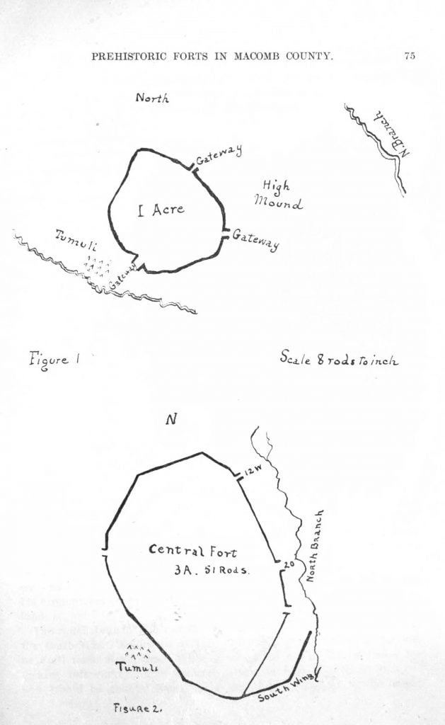
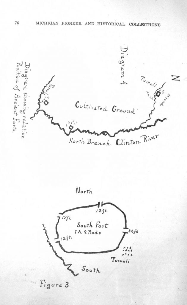
Except for the ravages of time, these when first seen were in the same condition as when left by the builders. The native forests had covered these works, trees of large size were found growing in the area, in the ditch, and on the embankment. The earth was thrown up into a ridge several feet wide at the base and about four feet in height from the bottom of the trench. Gateways or openings in the embankments were found in each enclosure which were called by the first settlers Indian forts. The fact that the outline of these interesting structures have been proved to us is entirely due to the effort, public spirit and forethought of Dr. Dennis Cooley who caused a survey to be made as early as 1827 or 1828. At that date the axman had not done his work nor the plow leveled the embankment. Mr. John B. Hollister, county surveyor for Macomb County was employed to make the survey. As I write the report is before me, dated April 10, 1830; the ink is scarcely faded, the distances and courses along the embarkment are easily made out and are shown in the diagrams, figures 1, 2, 3, and 4.
Figure 4 shows the relative position of the structures as I found them forty-five years later. Mr. Hollister was slow in making out his report and appears to have required much urging. I copy that portion of his letter which shows how he got even with the Doctor’s prod-ding, and I imagine a satisfactory smile crept over the Doctor’s face as he read it. “I have no apology to offer, my dear sir, nor anything like an apology, as that would be entirely useless as I am sensible it would add insult to injury; suffice to say that I have procrastinated from day to day, month to month and from year to year. Now if you will forgive this long neglect of mine / will pray when I think the Gods will hear me that all your frailties may be forgiven at the great bar of retribution.” We are thankful that the Doctor got the report as it is, I believe, the first authentic survey ever made of such structures in Michigan. From this we learn that the north fort, diagram I, is situated on the east half of the northeast quarter section 3, 25 north range 12 east, now township of Bruce. It is near the north line of the section and its area was a little over an acre. The embankment had three openings, supposed to be gateways of ten, twelve and fifteen feet in width, as seen in plan. A small brook flowed southeasterly near to its south border. The country in its immediate vicinity is quite level, but becomes more rolling within a mile to the westward. The north branch of the Clinton River was less than a mile to the east The flat land to the southward showed signs of cultivation. The embankment had been made by throwing up the dirt from the outside, except along the south side, when at my visit it was scarcely traceable. The whole structure was covered with the native forest and at that date had been undisturbed since its builders had left it. The first settlers report the existence of a large circular mound, situated a few rods to the east, of sufficient height to overlook the entire country for a considerable distance, supposed to be used as a watchtower. The embankment measured very nearly 800 feet including the openings, and so far as I am aware may be seen today substantially as when the survey was made eighty years ago.
The large or central fort, as we may consider it, was in a direct line some three miles distant to the southeast, diagram 2 situated on elevated ground on the right bank of the river, and had an area of three acres and fifty-one rods, aside from a wall some 200 feet in length, which the surveyor designated as the south wing. The circumference of the large work was 1,268 feet. There were three gateways of narrow width, two on the east near the river and one on the west side. The structure stood on an elevated plateau some ten feet above the river which flowed close along its eastern side. Within the area was a small pond, but nothing else of note was apparent. To the southwest and near the bank were many tumuli or small mounds, the supposed burying ground of the people. The whole structure it is said had an imposing appearance and must have stirred the imagination of the observer. This fort is situated on the west half of the southwest quarter of section 18, township 5 north of range 13 east as given by Mr. Hollister.
About a mile and a half to the southwest was found the third fort, diagram 3, its. location being on the west half of the northeast quarter of section 25 north range 12 east. This structure had four openings, two of twelve, one of fifteen and a large one of some eighty feet, which may have been an uncompleted wall near which were extensive tumuli. Its circumference was 870 feet and area included more than an acre of land.
The north branch was not far distant and a small stream was near the south side. Evidences of once cultivated ground were to be seen near all these structures. While great credit is due Mr. Hollister for making this survey he is strangely silent in regard to much that we now would be glad to know as he says not a word as to the height of the embankment, depth of the ditch, from which the earth was thrown, and other information which at that date was easily accessible, as all was there just as the builders left it, a minute examination would have been of interest to the archeologist of today. It is to be hoped that further research may bring to light other similar works elsewhere in our State. At present I know of but one similar structure, and that is situated a few miles below Detroit in Springwells. It is of about the same size and similar to Fort No. 1, described in this sketch. It is mentioned by Bela Hubbard in his Memoirs of Fifty Years who also gives an interesting account of mounds in its near vicinity.
That these structures were the work of many hands there can be no doubt. The erection of such extensive embankments without the aid of any tools with which we are accustomed must have required thousands of workers and for a long period of time.

Prehistoric Forts in Macomb County, Michigan, Figures 1 and 2 
Prehistoric Forts in Macomb County, Michigan, Figures 3 and 4
Source: Collections and Researches made by the Michigan Pioneer and Historical Society, vol. XXXVIII. Wynkoop Hallenbeck Crawford Co., State Printers, Lansing, Michigan, 1912.

I found 2 of these “Forts” and the Land is for Sale